Hazard risk management: physical assets, risks and geographic representation
Hazard Risk Management

MOBIUS HAZARD RISK MANAGEMENT

Informed decisions. Risks under control.

MOBIUS Hazard Risk Management supports the management of risk assets at the level of a locality, region or county, bringing together monitoring, collaboration and geographic representation.

Territoriallocality, region or county
Collaborativeprocedures, roles and responsibilities
WEB GISvisual representation of risks
Notifications & simulationalerts, scenarios and event reports
01 · Overview · Decision support and monitoring

A common picture of risks, assets and trigger factors.

The solution manages the physical assets exposed to risk and supports monitoring of the elements, causes and trigger levels that need to be tracked.

The way of working can bring together several organizations, each with its own roles and responsibilities, in a collaborative, procedure-based framework.

CentralizedInformation and assets in a common environment.
GeographicRisks visualized in a territorial context.
CoordinatedRole- and procedure-based participation.
HAZARDDecision support
Physical assetsTypes and map
AssessmentProbability and impact
MeasuresAnd owners
MonitoringFactors and triggers
DocumentsAttached to the risk
WEB GISLayers and zones
02 · What Hazard addresses · The organization's challenges

Questions answered within the same application.

MOBIUS Hazard Risk Management turns the everyday questions of decision-makers and participating organizations into verifiable information, in a territorial context.

“Which assets in the territory are exposed to risk?”
HAZARD
Answer in the platform: Physical assets are organized by type (for example localities, administrative-territorial units, roads, railways, healthcare facilities, power grids, water sources) and appear on the map, with their list alongside.
“How likely and how serious is each risk?”
HAZARD
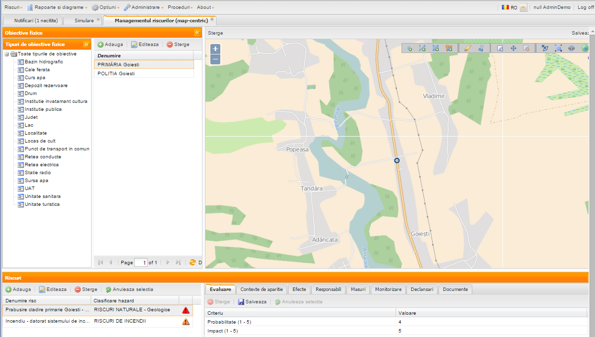
Answer in the platform: Each risk associated with an asset is assessed against criteria (Probability and Impact, on a scale of 1–5) and placed in a hazard classification, for example natural risks or fire risks.
“Who is responsible and what measures are taken?”
HAZARD
Answer in the platform: For each risk, the persons responsible and the associated measures are recorded and tracked within the established procedures, including across different organizations.
“What do we monitor and when does the risk level change?”
HAZARD
Answer in the platform: Monitoring tracks the relevant factors, and trigger levels record the thresholds that can signal a change in the risk level. The application sends notifications.
“Where are the affected areas and what happens if…?”
HAZARD
Answer in the platform: WEB GIS layers (for example floods, landslides, climate risks, nuclear risk, polluted areas) show the affected areas, and the simulation components and event reports support the analysis.
03 · Features · MOBIUS Hazard Risk Management

From inventorying exposure to tracking measures.

Risk information is organized around physical assets and operational responsibilities.

FEATURE 01

Physical assets

Managing exposed assets at the level of a locality, region, county or other administered territory, by asset type.

FEATURE 02

Risk assessment

Documenting the probability, impact and classification of the risks associated with each asset.

FEATURE 03

Contexts and effects

Organizing the causes, contexts of occurrence and effects that support operational analysis.

FEATURE 04

Responsibilities

Assigning the specific roles and responsibilities of the organizations involved in risk management.

FEATURE 05

Measures

Defining the measures associated with identified risks and tracking them within the established procedures.

FEATURE 06

Monitoring

Tracking the relevant factors and the evolution of the information needed to support decisions.

FEATURE 07

Trigger levels

Recording the thresholds and conditions that can signal a change in the risk level.

FEATURE 08

WEB GIS integration

Connection with WEB GIS systems for the visual representation of risks and affected areas, by layers.

04 · The operational cycle

Information follows a coherent path, from territory to decision.

The stages can support the procedures and roles specific to each participating organization.

01

Location

assets and zones

02

Identification

risks and causes

03

Assessment

probability and impact

04

Monitoring

factors and thresholds

05

Decision

measures and responsibilities

A risk record in MOBIUS Hazard

A risk associated with a physical asset, with a hazard classification
AssessmentAssessment criteria: Probability (1–5) and Impact (1–5).
Contexts of occurrenceThe conditions and causes in which the risk may arise.
EffectsThe possible consequences for the asset and the territory.
Responsible partiesThe organizations and roles involved in risk management.
MeasuresThe measures associated with the risk and their tracking.
MonitoringThe factors and information tracked over time.
TriggersThe thresholds and levels that signal a change in risk.
DocumentsThe documents associated with the risk, in one place.
05 · Multi-organizational operation · Participants work in the same operational picture

Risk management frequently involves several organizations.

MOBIUS Hazard Risk Management supports their collaboration through roles, responsibilities and procedures adapted to the context.

TERRITORY
Data organized around physical assets and the territory.
ORGANIZATIONS
Distinct responsibilities for the participating organizations.
PROCEDURES
Procedures that can cross the boundaries of a single organization, with links between assessments, measures, monitoring and documents.
01

Record

Add the relevant physical assets and territorial data.

02

Assess

Associate risks and record the probability and impact.

03

Distribute

Assign roles and responsibilities to participants.

04

Monitor

Track the causes, factors and trigger levels.

05

Decide

Correlate the information and the measures needed for intervention.

06 · Benefits · Risk becomes easier to understand
Risk becomes easier to understand when assets, causes, effects and responsibilities are visible in the same territorial context.
Territorial contextAssets and risks located on the map.
Operational pictureData brought together to support decisions.
Coordinated rolesCollaborative participation across organizations.
GIS integrationVisualization of zones and risk types.
07 · The application at work

Risks and physical assets, visualized in a geographic context.

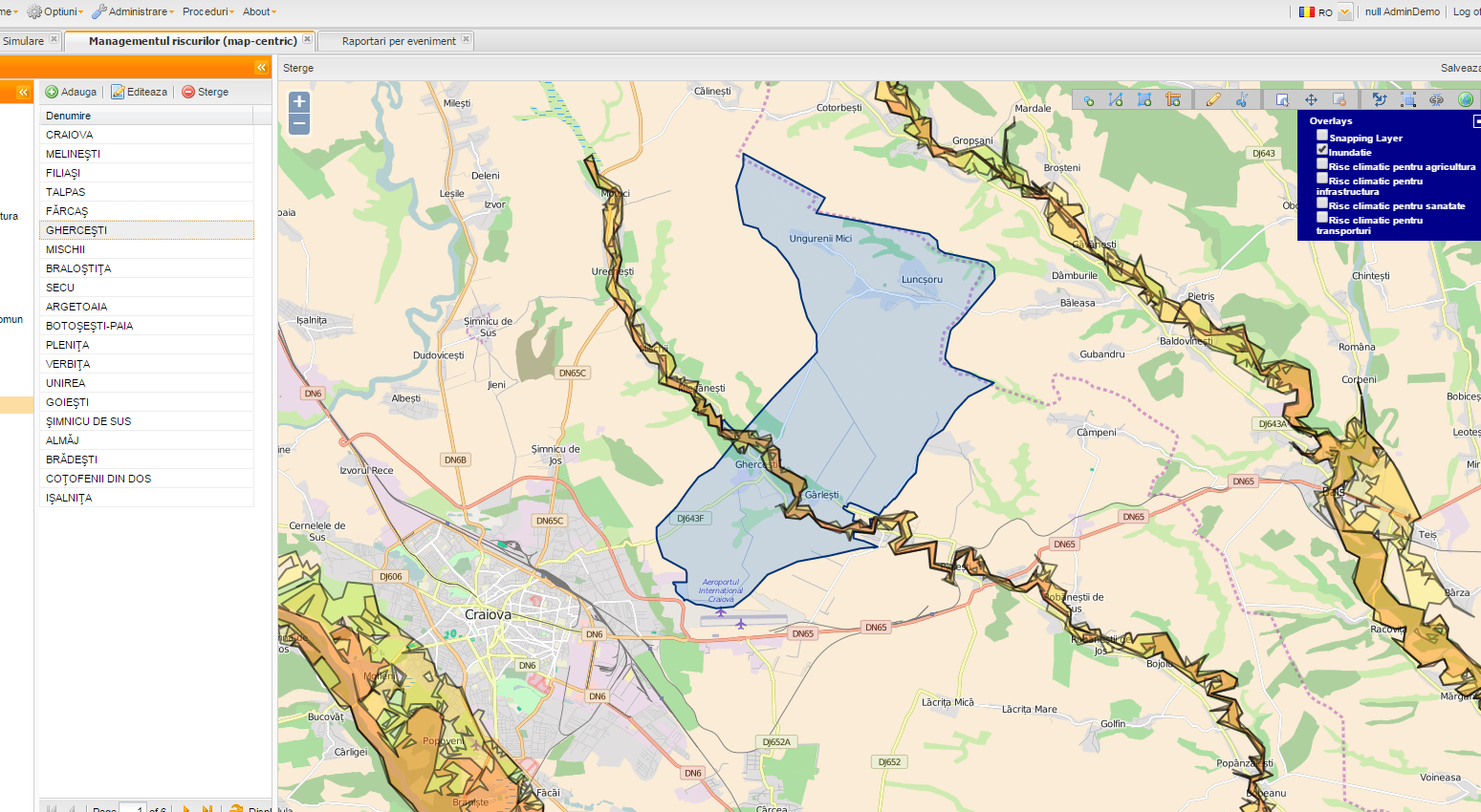
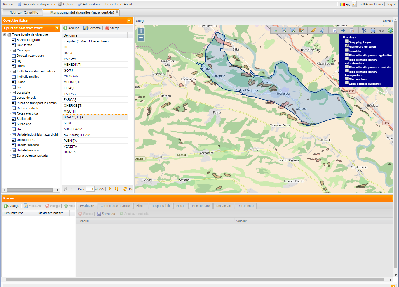
The original MOBIUS Hazard screenshots show the organization of assets, risk assessment and the overlay of territorial information. Each image is shown in full.

Geographic layers (overlays) visible in the application: floods, landslides, climate risks (agriculture, infrastructure, health, transport), nuclear risk, areas polluted with oil. In the menu: Risks · Reports and charts · Options · Administration · Procedures, plus notifications, simulation and event reporting.
08 · Confirmed fields of application

A solution used in contexts where coordination is essential.

Emergency situations

Implementations at county committee level for managing territorial risks.

The oil industry

Use in industrial contexts where physical assets and risks must be tracked in a coordinated way.

Epidemiological monitoring

Integration with epidemiological simulation and modeling components to support analysis.

Infrastructure and services

Configurable asset types: localities, roads, railways, networks, water sources, healthcare facilities, industrial facilities.

Integration in the MOBIUS solutions ecosystem

09 · Phased implementation · Our involvement at every step

Guided implementation, from procedure analysis to day-to-day use.

The Mobius team accompanies the participating organizations from establishing procedures to training users and supporting operation.

Code
Stage
What we do together with your team
Result for the organization
E1
Analysis and proceduralization
Identifying assets, risks and participating organizations; establishing working procedures.
✓ Clear roles and procedures
E2
Configuration
Types of physical assets, hazard classifications, assessment criteria, roles and access rights.
✓ A system aligned with the organization
E3
Territorial data and GIS
Loading assets and integrating the WEB GIS layers relevant to the territory.
✓ A unified territorial picture
E4
Procedures and notifications
Responsible parties, measures, monitoring, trigger levels and notifications.
✓ An active operational cycle
E5
Training and support
Training for users and administrators; usage assistance.
✓ Autonomous users
10 · Let's start now · Contact & Assessment

Build a shared picture of the risks and responsibilities in the territory.

We help you from establishing procedures and configuring assets to the day-to-day use of the application. Talk to the Mobius team about your territory and organizations.

Direct Phone (Monday – Friday, 09:00 – 18:00)+40 722 377 877
Call now →
Commercial & Technical Emailoffice@mobiussoftware.ro
Open Mail app →

Request a presentation or an analysis for MOBIUS Hazard

Fill in the form and your request is sent directly from the site to the Mobius Software team.